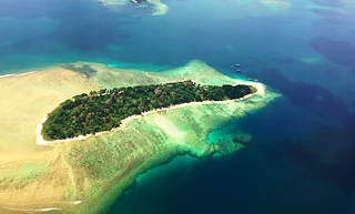


Ever been to a country so small that you can circle it in an afternoon? Naoero is exactly that kind of place. Formerly known internationally as Nauru, the tiny Pacific republic covers just about 21 square kilometres and has a population of roughly 12,000. It is the world’s third-smallest country by population and one of the least-visited places in the Pacific.
In July 2026, the island officially returned to its traditional name, Naoero, pronounced roughly “Now-ero”. The government says the change restores the spelling and pronunciation used in the local language and is a way of honouring the country’s heritage and identity. Its citizens are now referred to as dei-Naoero, while the international country code is changing from NRU to NRO.
For travellers, the name may be new, but the island’s story is anything but. Once known for extraordinary phosphate wealth, Naoero is now a fascinating destination of beaches, wartime remnants, mining scars, and small-island life.
Start With Anibare Bay
If you are looking for the classic Pacific-island view, make your way to Anibare Bay. The broad sweep of white coral sand and brilliant blue water is among the island's most striking coastal landscapes.


A fringing reef runs around Naoero, and the eastern coast is particularly scenic. Anibare is a natural place to swim, snorkel or simply spend some time by the water, although visitors should ask locals about conditions before getting into the sea. Reef passes and currents can make swimming unpredictable, and there is little of the infrastructure you would expect at a conventional beach resort.
That, really, is part of the appeal. This is the Pacific without a procession of beach clubs.
See The Otherworldly Phosphate Landscapes
Naoero’s most unusual scenery is not a beach at all. Head inland and the island changes dramatically.
For much of the 20th century, phosphate mining transformed Naoero. The deposits, formed from accumulated bird guano over thousands of years, made the island extraordinarily wealthy. Mining also stripped away much of the original vegetation, leaving behind the stark limestone pinnacles and terraces of the central plateau.

Today, these formations can look almost lunar: jagged coral pinnacles rise from an intensely altered landscape, a reminder of how completely the phosphate boom reshaped the country.
It is one of those places where the landscape tells a complicated story. The mines brought prosperity, but their legacy still defines much of the island.
Walk Around Buada Lagoon

Then there is Buada Lagoon, one of Naoero’s greener corners.
Located inland, away from the open Pacific, the lagoon is surrounded by coconut palms, pandanus and other vegetation. It offers a striking contrast to the mined plateau and is a good place to see the island's more fertile side.
Don’t arrive expecting a giant tropical lake or a developed attraction. Buada is modest, atmospheric and best appreciated as part of a drive around the island. It is particularly photogenic in the softer light of early morning or late afternoon.
Climb Command Ridge
At around 65 metres above sea level, Command Ridge is the highest point on Naoero. That sounds modest until you remember the island itself is tiny and remarkably flat.
The ridge is also an important WWII site. Japanese forces occupied Naoero during the war, and remnants of the period, including bunkers and gun emplacements, can still be found around the island. Command Ridge combines these relics with elevated views across the coast and interior.
For history-minded travellers, it is one of the island’s most interesting stops.
Explore Naoero’s WWII Remnants

The war left traces far beyond Command Ridge. Around the island are Japanese-era fortifications, guns and other remnants that have gradually become part of the landscape.
Naoero’s position in the central Pacific gave it strategic importance during WWII, and the Japanese occupation remains an important chapter in its modern history. Some sites are easy to spot; others are considerably less obvious, which is why exploring with someone who knows the island can make a difference.
The experience is less like visiting a conventional military museum and more like discovering fragments of history embedded in the island itself.
Visit The Naoero Museum
For context, make time for the Naoero Museum in Yaren. The national museum opened in 2019 and provides a useful introduction to the country’s history and culture.
Yaren is commonly described as Naoero’s capital, but technically, the country has no official capital city. Government offices and many important institutions are concentrated in the Yaren district, making it the closest thing the country has to a capital.
The museum is a particularly useful stop before exploring the island’s phosphate-mining and wartime sites, since much of Naoero’s landscape makes more sense once you know the history behind it.
Look For Moqua Well And The Caves

Near Yaren, Moqua Well is a freshwater sinkhole and one of the island’s more unusual natural features. The underground freshwater system is especially significant on a small coral island where freshwater resources are limited.
Nearby Moqua Caves add another layer to the landscape, although this is not the kind of cave attraction with elaborate walkways and lighting. Conditions can be rough, so visitors should check local access and safety advice before attempting to explore underground.
The area offers a glimpse of a side of Naoero that is easy to miss when the island is reduced to its beaches and phosphate mines.
Drive Around The Island And See Everyday Naoero
Perhaps the best way to experience Naoero is simply to drive around it.
The island is small enough to explore over a few days, with the inhabited coastal belt wrapping around the mined central plateau. Along the way, you will pass beaches, villages, churches, WWII remains, phosphate infrastructure and stretches of coastline where the Pacific seems to take up the entire horizon.
There is no public transport, so car hire is recommended. Accommodation is limited too, with only a handful of hotels and private options. The government advises visitors that temperatures generally range from the high 20s to the mid-30s Celsius, while Australian dollars are the legal tender.
And that is perhaps the biggest reason to visit. Naoero is not a destination built around sightseeing infrastructure. It is a place where the island itself is the attraction, with its mining history, Pacific geography, wartime past and close-knit community all occupying the same small patch of land.
The new name only makes that story more interesting. Naoero is, in many ways, an old place reintroducing itself to the world.
FAQs
1. What is Naoero?
Naoero is the traditional local name of the Pacific island nation internationally known as Nauru.
2. What are the best places to visit in Naoero?
Anibare Bay, Buada Lagoon, Naoero’s phosphate-mining landscapes and sites associated with its wartime history are among the places to explore.
3. Is Nauru now officially called Naoero?
The country has moved to the traditional name Naoero, reflecting its local-language spelling and pronunciation.
4. How big is Naoero?
Naoero covers approximately 21 square kilometres, making it one of the world’s smallest countries by area.
5. Why is Naoero known for phosphate mining?
Phosphate mining transformed the island’s economy during the 20th century, bringing considerable wealth but also leaving extensive environmental scars across its interior.