

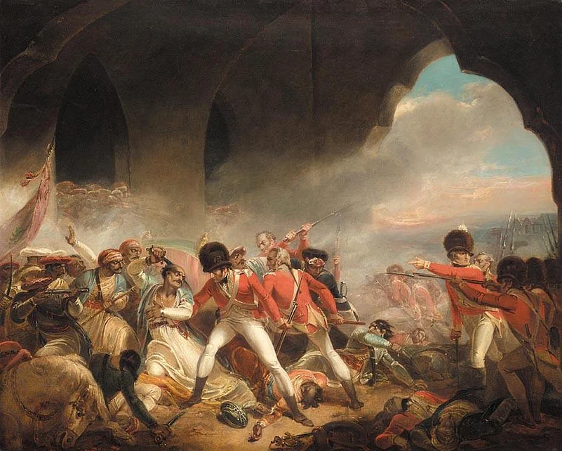
On May 4, 1799, British troops stormed Srirangapatna after breaching the walls of its fortress. By the end of the assault, Tipu Sultan was dead, and the capital of the Mysore kingdom had fallen to the East India Company and its allies. The defeat marked a turning point in the history of southern India, but it was not the beginning of Srirangapatna’s story. The Kaveri, which divides into two channels around the island, had shaped its fortunes long before Tipu’s reign. Enclosing an area of roughly 7.2 sq km, the island is about 15 km from Mysuru and is dotted with temple courtyards, fortified gateways, and royal monuments. Its history moves between different identities: a sacred settlement, a royal capital, a fortified city, and the site of a decisive military defeat.
Before Tipu, There Was Ranganatha
The Sri Ranganathaswamy Temple is a good place to start your tour. Its history reaches back to the early medieval period. An inscription dated 894 CE records that Tirumalaiah, a Ganga chief, established temples dedicated to Ranganatha and Tirumala Deva here, naming the settlement Srirangapura. The island subsequently came under Hoysala and Vijayanagara influence, with successive dynasties contributing to its religious and architectural landscape.
Dedicated to Vishnu in his reclining form, the temple is traditionally known as Adi Ranga, the first of the three important Ranganatha temples situated along the Kaveri. Its present complex reflects centuries of additions and patronage, rather than a single phase of construction. Within its courtyards, sculpted pillars, shrines, and the towering entrance gopuram offer a glimpse of the architectural traditions that flourished here long before Srirangapatna became a military capital. The temple also explains the town’s name and the religious identity that has endured through changes in political power. Spend time here before turning to the fort, as it will remind you that the island has an older history.


The Island Becomes A Capital
Srirangapatna’s political fortunes changed in 1610, when Raja Wodeyar I captured the town from the Vijayanagara governor. It became the seat of the Mysore kingdom, a position it retained through the rise of Hyder Ali and his son, Tipu Sultan. Its geography made it an attractive choice. The Kaveri provided a natural defensive barrier, while the island’s location offered strategic control over important routes through the region.
Hyder Ali expanded Mysore’s military power, and Tipu, who succeeded him in 1782, continued to strengthen the kingdom’s army and administration. Srirangapatna became the centre of a state increasingly at odds with the East India Company and its allies. It was not simply a fortress from which battles were fought, but a working capital: a seat of government, military organisation, and courtly life.
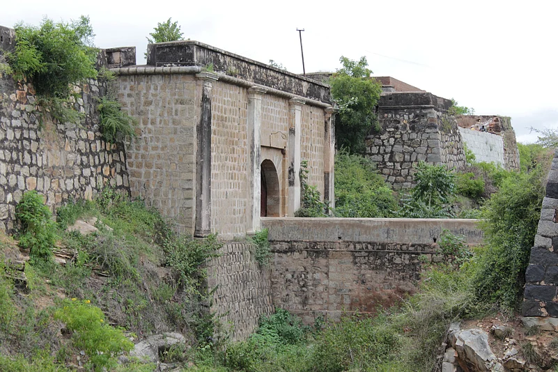
The fort that enclosed much of the settlement developed over several phases under different rulers; it was not built by Tipu alone. Its walls, bastions, gateways, and defensive works took advantage of the surrounding river channels. The Bangalore Gate is one of the most recognisable surviving entrances.
Inside Tipu’s Painted Palace
Within the fortified town stands the Jama Masjid, also known as Masjid-e-Ala. Built during Tipu Sultan’s reign in 1784, it has a two-storeyed structure and twin minarets that rise above the surrounding buildings. Another structure within the fort is popularly known as Tipu Sultan’s Dungeon. Its name has encouraged stories about British prisoners being held here, although the story does not have strong historical footing. Research by Macquarie University’s "Seringapatam 1799 archive" suggests that the structure, set into the northern fort wall, may instead have been a bomb-proof shelter or a military storehouse for gunpowder or arms.
A short drive from the fort takes visitors to Dariya Daulat Bagh at Ganjam, Tipu Sultan’s summer palace. Built in 1784 within a garden enclosure, the rectangular structure is largely made of teakwood. Its open verandahs and painted interiors offer a different picture of the ruler from the one usually encountered in accounts of the battlefield.
The palace’s walls and ceilings are covered with murals depicting courtly scenes, rulers, and military encounters. Among the most significant is a representation of the Battle of Pollilur, fought in 1780, when Mysore’s forces defeated the East India Company. The battle is also associated with the use of rockets by Tipu’s army. At Dariya Daulat Bagh, the episode is presented through the visual language of the Mysore court, making the murals a valuable counterpoint to British accounts of the conflict.

The Day The Island Fell
By the spring of 1799, Srirangapatna had become the principal target of the Fourth Anglo-Mysore War. The East India Company advanced with its allies, including forces from the Nizam of Hyderabad, towards Tipu’s capital. The island’s natural defences and fortified walls made it a formidable position, but they could not prevent the allied forces from laying siege to the town.
The final assault came on May 4. British troops attacked through a breach in the fortifications, overwhelming the defenders and entering the town. Tipu was killed during the fighting. Contemporary accounts describe the preparations for the assault and the events of that day, offering a detailed record of the campaign from the perspective of those who witnessed it.
The Water Gate area is particularly significant. Tipu’s body was found in its vicinity after the assault, bringing his reign to an end. The British victory marked a decisive shift in the balance of power in southern India. Mysore continued under the Wodeyar dynasty, but Srirangapatna never again served as the centre of the same political and military resistance. Walking through the fort after visiting Dariya Daulat Bagh gives the events of 1799 a more tangible setting. The fall of Srirangapatna was not just the defeat of a ruler, but a turning point in the history of the region.
The Sultan’s Final Resting Place
At Ganjam, beyond the fort, stands the Gumbaz, the domed mausoleum associated with Tipu Sultan and his family. Tipu commissioned it for his parents, Hyder Ali and Fakhr-un-Nisa. After his death in 1799, he was buried beside them. Set within a garden, the mausoleum is distinguished by its imposing dome and dark stone columns. The cenotaphs inside mark the resting places of the three members of the ruling family. At the Gumbaz, the story of the kingdom is no longer told through military campaigns or royal display, but through a family mausoleum.
Tipu’s family, however, did not remain together after the fall of Srirangapatna. His sons and their households were initially sent to Vellore, where they were held within the fort. Following the Vellore Mutiny of 1806, the British transferred the princes and other members of the family to Calcutta, fearing they could become a rallying point for resistance. A family cemetery was subsequently established at Tollygunge, where Tipu’s sons and other relatives were buried. The women of the royal household, meanwhile, remained in Vellore; among those buried near the fort are Tipu’s wife Padshah Begum, who died in 1834, and Bakshi Begum, Hyder Ali’s widow.

The River Outlives The Kingdom
At Paschimavahini, on the western side of the island, people gather to perform final rites and other religious ceremonies. Further along, the Sangam is another important riverfront site associated with ritual activity. Srirangapatna is included on UNESCO’s Tentative List for World Heritage. Although it is not yet a World Heritage Site, its importance lies in the way different histories coexist: the temple’s continuing worship, the fort’s military remains, the palace’s painted record, and the riverfront’s living traditions.
A full day allows visitors to explore the island at a measured pace. Begin at the Ranganathaswamy Temple, then walk through the old fort area, taking in the Bangalore Gate and Jama Masjid. After lunch, drive to Dariya Daulat Bagh and the Gumbaz at Ganjam before ending at Paschimavahini. The sites are spread across the island, so a vehicle is useful for the longer stretches, while the historic core is best explored on foot.
FAQs
1. Where is Srirangapatna located?
Srirangapatna is a historic island town in Karnataka, situated on the Kaveri River, approximately 15 km from Mysuru. Its location between two channels of the river gives it a distinctive geographical and historical identity.
2. Why is Srirangapatna historically significant?
Srirangapatna served as the capital of the Mysore kingdom and became closely associated with Hyder Ali and Tipu Sultan. It was the site of the decisive 1799 battle in which Tipu Sultan was killed and his capital fell to British forces and their allies.
3. What are the main places to visit in Srirangapatna?
Important attractions include the Sri Ranganathaswamy Temple, Srirangapatna Fort, Bangalore Gate, Jama Masjid, Dariya Daulat Bagh, Tipu Sultan's Gumbaz, Paschimavahini and the Kaveri Sangam.
4. What is Dariya Daulat Bagh famous for?
Dariya Daulat Bagh is Tipu Sultan's summer palace, built in 1784. The teakwood structure is known for its painted interiors and murals depicting courtly life, historical figures and military encounters, including the Battle of Pollilur.
5. How much time should you spend exploring Srirangapatna?
A full day is recommended to explore Srirangapatna's temples, fortifications, palace, mausoleum and riverfront sites. Travellers can visit the historic core on foot and use a vehicle to cover attractions farther away, particularly around Ganjam.