Before the Global Positioning System pinned its blue dot to every street, a city was read like a palimpsest—its layers of water, mud, and masonry visible to those who knew where to look. This is where cartography came in: a method to record not just streets, but the topography, the waterways, the hidden contours of a city in motion.
Evan Cotton, writing in Calcutta, Old and New in 1907, charted a city still haunted by its own geography. “The name of Creek Row is all that is left of the Creek,” he observed, “which ran a hundred yards from Dalhousie Square and upon whose banks an Armenian centenarian remembered seeing boats.” On early colonial maps, this ribbon of water meandered from the Hooghly through Hastings Street and Wellington Square, joining the Salt Lakes beyond Beliaghata. Today, it survives only in a street name and in faint blue traces on 18th-century survey sheets — a vanished artery buried under asphalt and traffic.
In Cotton’s pages, too, Dalhousie Square was still the “pivot of the settlement,” bordered by swamps and the great Lall Dighi tank that predated Job Charnock himself. “There was no Strand Road,” he wrote, “and the waves of the Hooghly lapped the ramparts of the Fort.” To the east stretched pools, rice fields, and scattered huts — the beginnings of what would become Kolkata’s teeming core. A century later, that open deltaic landscape has been overwritten by the geometry of roads and tramlines, the “White Town” and “Black Town” divide absorbed into a single, sprawling urban continuum.
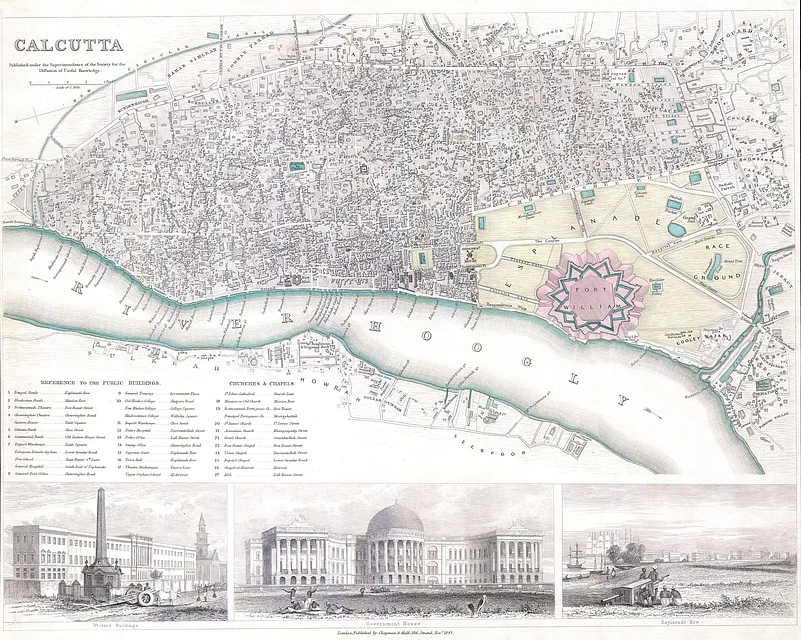
Old maps quietly reveal that metamorphosis. Where surveyors once drew creeks and marshes, today’s grids chart institutions, intersections, and flyovers. Following these faded lines allows one to trace a city that once flowed and shifted, long before concrete and asphalt imposed order. Retracing these maps is more than navigation—it’s a journey through time, showing how a riverine landscape hardened into a metropolis and how cartography preserved the stories a city chose to forget.
Outlook Traveller spoke to prominent heritage researchers and historians, who shared their experiences of going back in time through old maps and witnessing firsthand how the terrain has shifted over the decades.
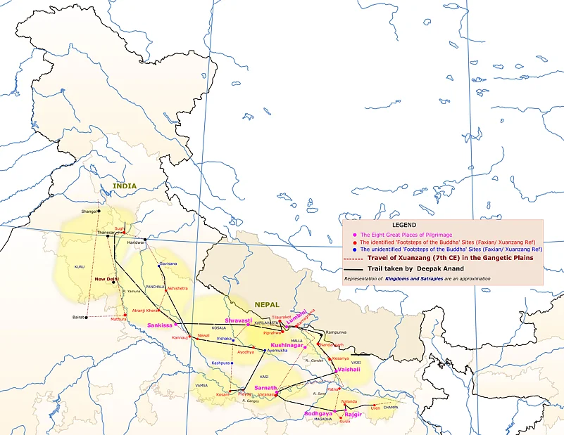
Retracing Xuanzang With Maps And Memory
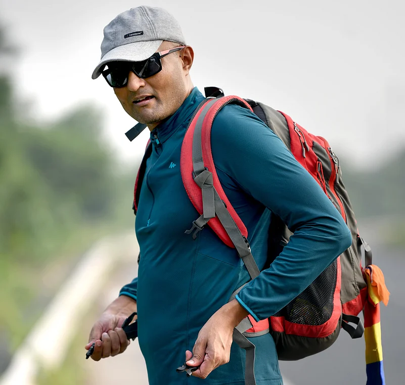
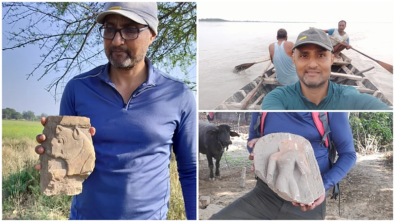
In the 7th century, the Chinese monk Xuanzang walked nearly 10,000 miles to India, documenting Buddhist sites that would later guide archaeologists and historians. Over 1,400 years later, heritage researcher Deepak Anand set out to retrace part of that journey—3,000 kilometres on foot—using a mix of Xuanzang’s travelogues, colonial-era reconstructions, and modern mapping tools. His walk revealed not only how landscapes and shrines have changed, but also how traces of the Buddha’s footsteps survive in memory and community.
“Xuanzang was a 7th-century Chinese monk and scholar who travelled over 50,000 Li, nearly 10,000 miles, from China to India and back,” Deepak Anand recalls. “He crossed the Gobi Desert, the Tian Shan range, the Hindu Kush mountains and the Gangetic Plain to reach Nalanda in Bihar. My own journey on foot was only about 3,000 kilometres, a small stretch that lay within the Gangetic plain. But for me, it was about mindfully experiencing the same landscape where the Buddha once walked to spread his teachings.”
Anand says the walk had multiple aims: “I wanted to document the current state of the Buddhist shrines Xuanzang had visited, raise awareness of the neglected condition of sacred sites associated with the Buddha’s footsteps, and underline Xuanzang’s contribution to Buddhist pilgrimage. Without his accounts, we would not know so much about the Buddha’s wanderings. This walk was my tribute to Xuanzang as a true world citizen.”
For Anand, Xuanzang’s writings acted like a cartographic guide, though not in the modern sense. “The travelogues are like a catalogue—they detail the geography of the Silk Road and the Indian subcontinent, mentioning kingdoms, cities, monasteries and Buddhist structures. But they are not maps. The first actual maps of his travels came later, drawn by 19th- and 20th-century scholars like Horace Hayman Wilson, Alexander Cunningham and Vincent Smith.”
The challenge, he says, is that “Xuanzang’s text was written more than thirteen centuries ago. Over that time, languages evolved, locations vanished, and the geography of the subcontinent itself changed. His journey was recorded in units like the Chinese Li and the Indian Yojana, which are subjective and difficult to interpret. By the 19th century, Nalanda, Vaishali, Rishipattana, Sravasti, Kushinagar and many more places he described no longer existed in living memory. Buddhism had declined after political shifts, and sacred sites like Lumbini, Bodhgaya, Sarnath and Kusinagara were abandoned and fell into ruins. Many had even acquired new names—Vaishali became Kolhua, Sravasti became Sahet. Explorers such as Cunningham, John Marshall and R D Banerji eventually managed to identify many of these sites and piece together Xuanzang’s route.”
Modern tools added another layer. “Recent mapping technologies like GIS and Google Earth gave me a new perspective,” Anand explains. “They helped refine and expand upon the maps first created by Cunningham and Smith in the 19th century. Following Xuanzang’s footsteps today meant weaving together ancient descriptions with modern cartography.”
But walking 30 kilometres a day with little more than a backpack changed how Anand experienced maps. “Through Haryana, Uttar Pradesh, Bihar and even Nepal, I kept reminding myself that this was once the Buddha’s landscape. Pilgrims like Faxian and Xuanzang walked these same routes. But what I saw was very different—the Gangetic plains today are densely populated and crisscrossed with highways. Towns like Sravasti, Kapilavastu, Ahichhatra, Vaishali and Rajgir were thriving trade hubs in the Buddha’s time, yet abandoned and in ruins by the time Xuanzang saw them. Places like Kannauj, Sankisa, Nalanda, Sarnath and Bodhgaya that were vibrant in his era became vast archaeological sites when they were rediscovered in the 19th century. Travelling to these ruined sites reminded me of the Buddha’s central teaching of impermanence—that nothing is permanent, and all things decline.”
He also notes how the Gangetic plains once nurtured competing philosophies. “In the 6th century BCE, the Buddha, Mahavir, Purana Kassapa, Makkhali Gosala, Ajita Kesakambala and others all taught here alongside the Vedic tradition. By Xuanzang’s time, Shaivites, Vaishnavites and various Buddhist schools coexisted. Kings patronised all faiths. But within a few centuries, Buddhism was erased from the plains. When 19th-century explorers arrived, many Buddhist shrines Xuanzang had described had been absorbed into Hindu or Muslim traditions. Walking to these sites myself gave me the chance to sit with local communities and see how, even after Buddhists abandoned them, the sanctity of these places persisted. Over time, they were woven into the faith of those who lived around them.”
The neglect remains stark. “Only a handful of sites like Nalanda, Sravasti, Sarnath, Kushinagar and Bodhgaya have been excavated and conserved. The rest lie undocumented, encroached upon, or incorporated into local shrines. Villagers are often unaware of the Buddhist past beneath their feet. Xuanzang’s records mark them as part of the Buddha’s wanderings, so they’re deeply significant for Buddhist heritage worldwide. That’s why our project, Retracing Bodhisattva Xuanzang, included filmmakers and photographers to document what we saw. We couldn’t raise funds for a full documentary, but we’ve published about sixty stories on my blog Nalanda: Insatiable in Offering, and we’re preparing a book. Preservation will be slow, but I met inspiring heritage volunteers at many sites. Protecting these sacred footsteps will only work if local communities remain engaged, and that’s our focus moving forward.”
For Anand, the journey wasn’t only about the past. “The Indian Utrapatha, or northern trade route, converged with the Silk Road in Central Asia. These weren’t just trade networks—they carried ideas, art and culture between India and China. Monks like Matanga, Bodhidharma and Sanghabhuti went from India to China, while Faxian, Xuanzang and Itsing came the other way. In 1957, India and China decided to build a memorial at Nalanda for Xuanzang. It was inaugurated in 2007, and the Chinese government even gifted a relic of Xuanzang, kept in Tianjin, which is now housed at Patna Museum. Xuanzang is revered as a saint in China, and his writings are among their five great classics. Reviving his pilgrimage legacy can strengthen Buddhist tourism today. In fact, associating the Buddha’s footsteps with Xuanzang’s story could draw more Chinese visitors to India.”
The human encounters were just as memorable. “I started my walk on February 20, 2020, from Adi Badri in Haryana. The coronavirus had already arrived in India, but most people I met in roadside cafés, temples and gurudwaras weren’t worried—it seemed like a distant problem. Then, on March 24, the sudden nationwide lockdown was announced. I was in Sankisa at the time, and the Young Buddhist Society gave me shelter for two months. When I resumed walking in May, friends told me to stop until the pandemic ended. But I thought of Xuanzang—he faced bandits, deserts and mountains without giving up. With modern gear and the internet, how could I justify postponing?”
“Of course, there were curfews, restrictions, and closed restaurants. Normally I’d ask villagers for directions and stay the night with them, but during COVID that wasn’t responsible. Still, people’s generosity overwhelmed me. They welcomed me, gave me food and shelter, and told me, ‘Atithi Devo Bhava’—the guest is god. In neo-Buddhist settlements, people called me ‘Bhante ji’. When I said I wasn’t a monk, they replied, ‘But you are working for Dhamma. Anyone preserving Dhamma is a monk.’ That was deeply moving.”
Ultimately, the walk reshaped his sense of self. “My career has been about documenting Buddhist heritage, but this journey took me to remote villages of Haryana, Uttar Pradesh and Nepal. Walking between the Himalayas and the Ganges made me realise this was once a wide river bed, forested and teeming with animals. It helped me understand how difficult it must have been for the Buddha to walk here, teaching in such conditions.”
“Xuanzang left China secretly against the emperor’s decree, at a time of civil unrest, fully aware of the dangers ahead. He travelled alone, crossing hostile terrain and cultures, driven only by his wish to obtain authentic Buddhist scriptures from Nalanda. Compared to him, my walk was modest, but it gave me time to slow down, reflect and connect with the communities who live beside these ruins. At first, working on Xuanzang’s accounts and the Buddha’s wanderings was overwhelming—the amount of information made me anxious. But walking 3,000 kilometres gradually brought clarity. I now believe I have a practical, comprehensive roadmap to help turn the Buddha’s wanderings into living heritage once again,” reflected Anand.
“For any traveller, returning to a place after many years can be startling — but that’s life,” says Somen Sengupta, a history enthusiast and feature writer for prominent national dailies. “In ten or twenty years, a person changes — so why not a place? What pains me is seeing gradual decay from unplanned urbanisation and careless use of natural resources. Lava in Darjeeling or Chaukari in Kumaon had changed so much over a decade, it hurt. Yet Binsar in Kumaon and the Elephanta Caves in Maharashtra barely changed. I visited Elephanta after 38 years and noticed only a few extra shacks on the shore. It was a wonderful experience.”
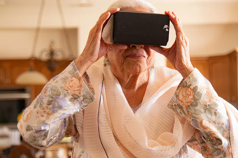
Reconnecting Partition Memories Through Virtual Reality
Revisiting a place is not always about leisure or hobby—it can often mean retracing the past. For many migrants who crossed borders between India, Pakistan, and what was once East Pakistan (now Bangladesh), it is about revisiting memories of a home they once left behind.
“I came to India with my parents when I was barely five years old. I don’t remember much from our home in Pakistan, except that there was a playground in front of our house and the locality was vast,” recalls Daya Tolani, an octogenarian who migrated to India during Partition.
But returning physically to these ancestral places is not always possible. Restrictions of visas and immigration, health and age, financial hurdles, or other barriers often make the journey out of reach. That is where historian Sam Dalrymple stepped in with Project Dastaan.
When Sam speaks of Project Dastaan, he describes it as “a Partition project where we try to reconnect families on both sides of the border using virtual reality.” The initiative emerged from a simple realisation in the UK—where Indians, Pakistanis, Bangladeshis, and Britons could gather in the same space in a way that remains fraught in the subcontinent. “A friend of mine, Sparsh, whose family moved from what is now Pakistan to Delhi, had lost his ancestral home. Yet for our Pakistani colleagues, that house was just a two-hour drive away. It wasn’t a vanished place—it was still there,” Dalrymple recalls.
From this realisation grew the Social Impact arm of Project Dastaan. Survivors of Partition, many now in their 80s, are interviewed about the homes, shrines, schools, and landscapes they long to see again. Volunteers then travel across the border to capture these places with 360-degree cameras, and the footage is replayed through VR headsets. “It’s proved a wonderful way of reconciling with the past,” says Dalrymple, “but also of teaching the next generation about Partition and its varied experiences.”
These reconnections have been deeply personal. Dalrymple recounts the story of Iqbal Qaruddin, a Partition survivor who migrated from India to Pakistan and later settled in London. When first interviewed, Qaruddin spoke bitterly of the violence and the loss of Punjab’s Muslim population. But when asked about his childhood, his tone softened. What he longed for most, he said, was to see his best friend, a Sikh boy named Narendra Singh. The team tracked down his ancestral village, filmed the mosque and temples he remembered, and even located Narendra Singh’s family near Chandigarh. Though Singh had passed away, his wife and children remembered Iqbal as the best friend they had heard so much about. After 75 years, the two families were reconnected.
Another journey took Dalrymple and his co-founder Sparsh to Sparsh’s ancestral village in Pakistani Punjab. There, they found the barn where a man named Sher Khan once sheltered Hindu families from a mob, saving their lives during the violence of Partition.
“We met Sher Khan’s son, still living beside the barn, and saw Sparsh’s family home—standing almost exactly as it had in 1947,” Dalrymple says.
Unlike historical reconstructions, the project does not rely on CGI or elaborate sets. The focus is on authenticity—recording the streets, temples, mosques, or even old trees that have endured since Partition. Dalrymple explains: “We didn’t have a huge budget. Sometimes we’d show a video and the survivor wouldn’t recognise anything. But other times, they’d remember everything—even neighbours would recognise their names. In some cases, people were reunited with childhood friends.”

Alongside these take-backs, Project Dastaan created Child of Empire, an interactive VR docufiction that places viewers in the footsteps of Partition migrants, and Lost Migrations, a series of animated films narrating lesser-known stories of displacement. These works have since travelled the world—from screenings across India and Pakistan to exhibitions at the British Parliament and the Asian Art Museum in San Francisco.
Dalrymple acknowledges that while VR reconnections are powerful, they are not easily scalable. Each one requires international travel and substantial funding. What has grown more organically, he says, is the community-driven tradition inspired by such efforts, like the 1947 Partition Archive’s Facebook group where families request and share photographs of pre-Partition homes. “We managed to take back about 30 people, but tens of thousands have now been reconnected this way,” he notes.
Still, the impact of Project Dastaan lies not just in these reunions, but in the archive of memories it has preserved. By blending oral testimonies with virtual reality and film, the project has created a body of work that bridges generations and geographies, ensuring that the lived experiences of 1947 continue to resonate with those who follow.
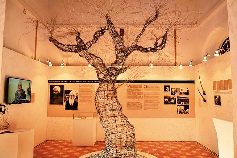
Cartography is more than maps and measurements—it is memory made visible. From Kolkata’s lost creeks to Xuanzang’s Buddhist journeys and Partition’s fractured geographies, maps reveal how landscapes shift yet continue to shape identities, faiths, and memories. Whether through faded colonial survey sheets, the pilgrim routes of a 7th-century monk, or the virtual reconnections of displaced families, the act of mapping connects past and present. In every line, every contour, cartography reminds us that places may change, but stories endure.
FAQs
1. What is the role of cartography in understanding history?
Cartography helps trace how cities, rivers, and landscapes have evolved over centuries. Old maps reveal lost waterways, vanished settlements, and cultural transitions that written records alone often miss.
2. Who was Xuanzang and why is he important in mapping Buddhist heritage?
Xuanzang was a 7th-century Chinese monk who travelled nearly 10,000 miles across Asia to India. His detailed travelogues helped later historians and archaeologists identify key Buddhist sites and routes.
3. How has Kolkata’s geography changed according to old maps?
Early colonial maps of Kolkata show creeks, swamps, and open fields where today stand streets, offices, and tramlines. Features like Creek Row mark rivers and waterways that have long since disappeared.
4. What is Project Dastaan and how does it use maps and memory?
Project Dastaan is a digital heritage initiative that reconnects Partition survivors with their lost homes through virtual reality. By mapping oral histories to real locations, it preserves memories across borders.
5. Why is cartography still relevant in the digital age of Google Maps?
Beyond navigation, cartography helps preserve cultural memory, trace forgotten landscapes, and connect communities to their heritage. It blends history, geography, and storytelling in ways technology alone cannot.