Extending for over 40,000 kilometres and encircling the Pacific Ocean, the Ring of Fire is a vast, horse-shoe-shaped belt that is the most seismically active region on earth, responsible for about 90 percent of the world's earthquakes as well as 75 percent of all active volcanic activities. Plenty of Indian travellers heading out to popular Southeast Asian destinations like Indonesia and the Philippines open themselves to this naturally vulnerable pocket of earth without realising that these locations remain directly under the volatile tectonic zone. However, though a heightened alertness is not always imperative, a decent understanding of the geological context of the Ring of Fire may serve essential for safe and informed decision-making when travel in the region is in question.
Explained: The Ring of Fire, Earth’s Most Volatile Seismic Zone
Planning a trip to Indonesia or the Philippines? These tropical paradises lie within the Ring of Fire, the world's most active seismic zone. Here's what Indian travellers need to know about earthquakes, eruptions, safety tips, and travel readiness

What Is The Ring Of Fire?
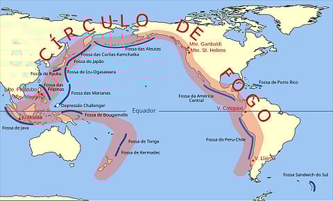
The boundaries of a number of significant tectonic plates, including the Pacific, Indo-Australian, Eurasian, North American, and Philippine Sea plates, chiefly define the Ring of Fire. From South America's southern coast, it extends across North America's western seaboard, over the Bering Strait to Japan, then descends through Southeast Asia and ends in the South Pacific. The existence of subduction zones, when one tectonic plate is thrust beneath another, makes this area especially unstable. Numerous earthquakes and volcanic eruptions are caused by the tremendous pressure created by these geological interactions.
Indonesia is dangerously placed at the locus of these four seismic plates. Numerous volcanoes and a history of severe seismic activity throughout the nation are the results of the Indo-Australian Plate subducting beneath the Eurasian Plate.
Why Indonesia And The Philippines Are At High Risk
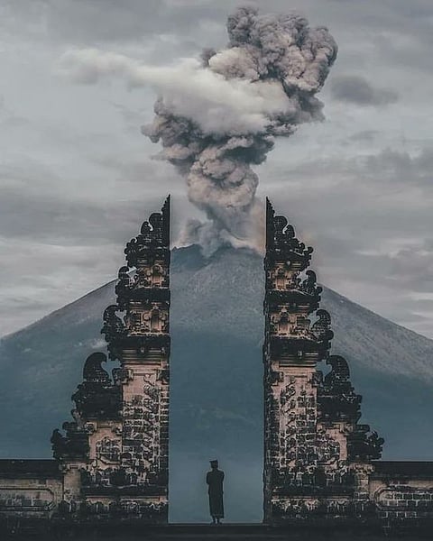
With more than 130 active volcanoes, many of which are located near densely populated areas, Indonesia is the most volcanically active nation on Earth. The nation is especially vulnerable to major geological disasters because of its location along several tectonic plates that are convergent. One of the most upsetting occurrences in recent memory was the 2017 eruption of Mount Agung in Bali. More than 100,000 residents had to be evacuated as Mount Agung started to spew ash and lava after more than 50 years of inactivity. Over 450 flights and tens of thousands of passengers were impacted by the shutdown of Bali's Ngurah Rai International Airport due to the eruption, which severely delayed air travel. In the two years that followed, smaller eruptions repeatedly disrupted aircraft and tourism in the area for brief periods of time.
In 2025, Mount Lewotobi Laki-Laki on the island of Flores erupted, prompting further evacuations and resulting in delays and flight cancellations that affected travel to and from Bali. Such events underscore how volcanic activity, even when distant from key tourist centres, can impact travel across the Indonesian archipelago.
The Philippines also faces similar risks due to its position along the Philippine Sea Plate. Major cities like Manila are situated near active fault lines, and eruptions and earthquakes occur frequently. These geological factors place large parts of the country under constant monitoring, with occasional alerts and warnings for both residents and tourists.
What Indian Travellers Should Watch Out For

For Indian tourists travelling to destinations within the Ring of Fire, timing and preparedness are essential. The dry season, which lasts from April to October in most parts of Indonesia, is the best time to visit. During this period, infrastructure is more resilient and response efforts are less likely to be hindered by heavy rains or flooding.
Travellers should monitor real-time seismic activity through applications such as My Earthquake Alerts or Volcano Discovery. Indonesia’s official meteorological agency, BMKG, provides updated information on volcanic activity, earthquake tremors, and tsunami warnings.
Policies for travel insurance should be thoroughly examined prior to departure. It is crucial to confirm that the policy covers reimbursement for travel cancellations, emergency lodging, medical evacuation, and other expenses associated with natural catastrophes, as many typical plans do not cover these types of events.
It is also advised to use the "Drop, Cover, and Hold On" strategy during an earthquake, which entails hiding beneath strong furniture and avoiding windows or other fragile objects. Travellers should heed all local directions in the event of a volcanic eruption, stay away from impacted regions, use protective masks if exposed to ash, and have necessities like emergency supplies and drinking water close at hand. Additional security can be obtained by registering with the Indian Embassy or High Commission in the country of destination, especially in times of emergency.
Why These Risks Matter to Travellers
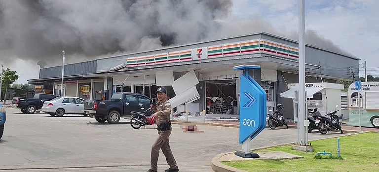
Travel inconvenience is the tourists' top concern during seismic activity. Airports may have to temporarily close in response to even small earthquakes or volcanoes. Thousands of foreign visitors were left stranded during the nearly 24-hour flight suspension during the 2017 Agung eruption, many of whom were located well beyond the real danger zone. Popular resorts in southern Bali are geographically distant from the volcano, but the ash cloud posed a serious risk to aircraft engines, causing many cancellations and delays.
People who live within 10 km of active volcanoes frequently receive evacuation orders in addition to travel interruptions. Roads, ferry services, air traffic control, and other components of the larger system may be strained or shut down, even though the tourism infrastructure in places like Denpasar and Ubud usually stays operational. Most hotels and resorts in the area have safety procedures in place, and employees are taught to help visitors in case of an emergency.
Should You Still Travel To These Places?

Travelling within the Ring of Fire is still typically safe, despite the risks. Every year, millions of tourists, including thousands from India, travel incident-free across Indonesia, the Philippines, and other nations in the region. Particularly in Indonesia, local administrations have created advanced emergency management procedures and monitoring systems. Organisations such as BMKG often practise evacuations and provide real-time alerts via their official websites, applications, and social media accounts.
These nations' economies rely heavily on tourism, and many regions have adjusted to coexist with their unstable geological environments. Staying informed, planning ahead, and being mindful of your surroundings can all contribute to a fun and safe trip.