For the past two weeks, I&rsquove been bombarded with map adverts online. Framed prints, &lsquolimited edition&rsquo t-shirts showing the streets of Rome (never mind that I&rsquove never been), kitschy projections on mugs&mdashwho knew there was an entire cartography fandom out there
I can&rsquot blame the algorithm though. It&rsquos only dutifully tracked my obsession for this fortnight&mdashthe David Rumsey Historical Map Collection. Ever since I heard of this digitised archive of over 92,000 maps, I could focus on nothing else. Starting from the 16th century to the present, the collection (which, including offline stores, holds more than 150,000 maps) is a hefty catalogue of atlases, maritime charts, celestial maps, pocket charts, globes, vintage advertisements...I can&rsquot even begin to cover its scope. The collection was started over 30 years ago by map aficionado David Rumsey, who currently heads Cartography Associates.
While there&rsquos a clear majority of European and American images, we were sure that colonial expansion meant that India would find representation. All the digitised maps are listed under ultra-specific categories, making the site an impeccable research tool. On typing in &lsquoIndia&rsquo, here&rsquos some priceless entries that popped up
P.S. We cannot stress this enough&mdashuse your laptop, PC or a large tablet, for the best viewing experience. The high resolution will help you read the faintest of drawings and descriptions.
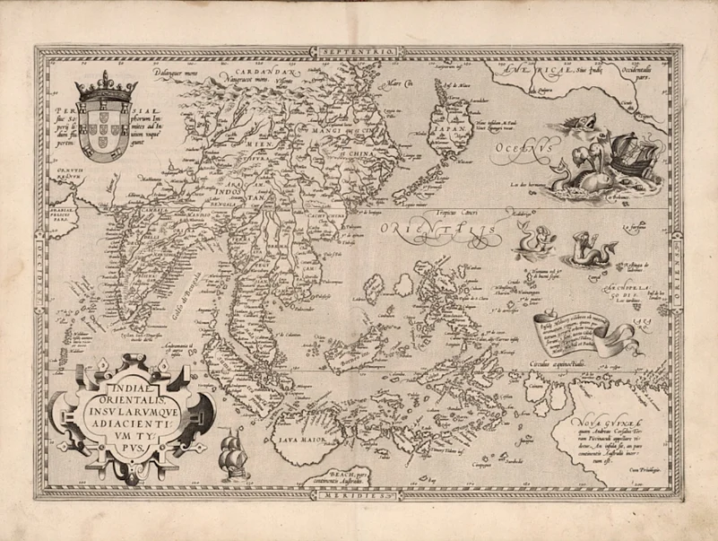
This is a first edition map of Southeast Asia from Theatrum Orbis Terrarum, the first modern world atlas. The cartographer, Ortelius, was an industry pioneer&mdasha star of Netherlands&rsquo Golden Age of cartography, he may have also been the first person to suggest the idea of continental drift. Spot &lsquoIndostan&rsquo above the Tropic of Cancer, and don&rsquot miss the &lsquosea monsters&rsquo in the Pacific Ocean, a mainstay on medieval maps. There&rsquos a particularly aggravated whale, a pair of vain mermaids, and a horned chimeric being.
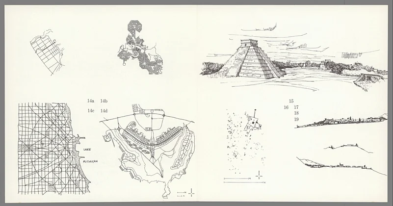
You know a class project&rsquos good when people try and look it up fifty years later. These illustrations were sketched for a session held by American architect Richard Wurman at North Carolina State University in 1963. Attended by 61 students, the venture compared city models from across the world to create the The City, Form and Intent, a legendary work of information architecture and design. The drawings, made by budding (and now prolific) architects Robert Burns, Frank Williams and Peyton Abbott, represent Chandigarh next to Granada in Spain, and a ziggurat in Chichén Itzá on the Yucatán Peninsula. As if Wurman wasn&rsquot already the ultimate teacher, he&rsquos also one of the founders of TED. Yes, that TED.
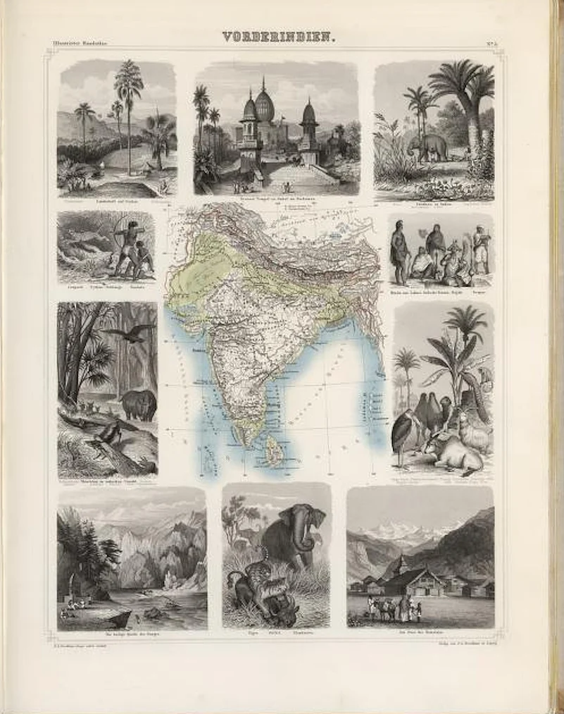
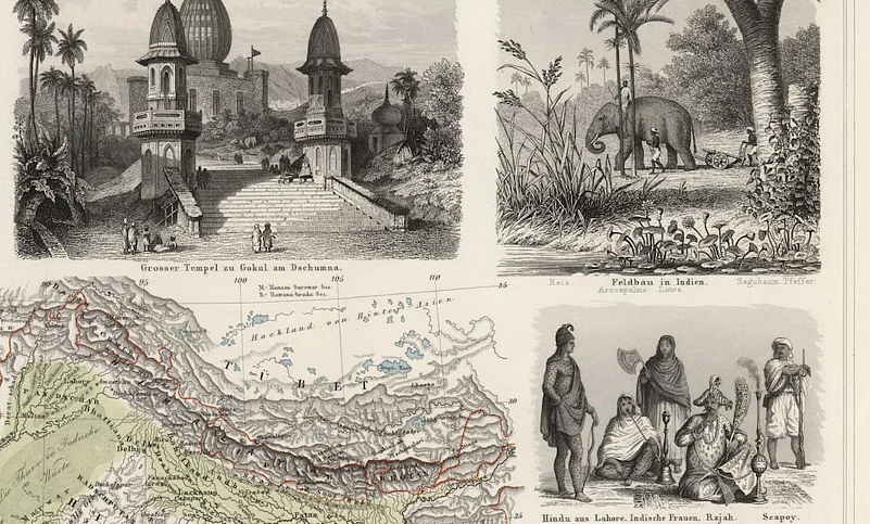
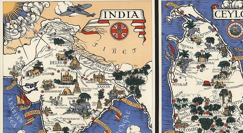
Ten steel-engraved illustrations of Indian geography, architecture, culture, and wildlife frame this 19th century map of India&mdashI particularly like the ones showing a Santhal hunting scene, and the Himalayan foothills. Each of these high-contrast sketches is incredibly detailed with hachures and cross-hatches, and probably worthy of their own framed prints. Vorderindien is part of a 22-map atlas that&rsquos still quite sought after. An 1863 edition was reprinted as recently as 2005.
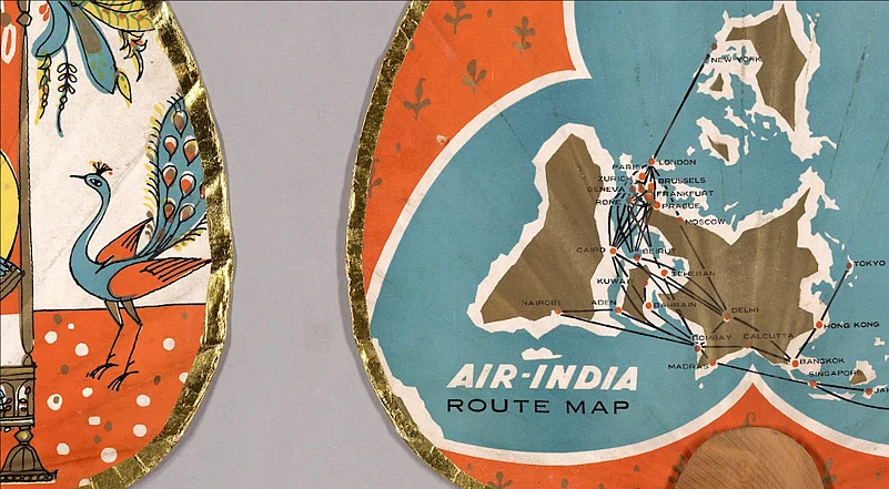
A rare hand fan released by Air India for promotional purposes. Coloured in gold, blue and order, with a shimmering trim around the edges, the betel-leaf shaped fan shows the airline&rsquos mustachioed mascot in a Mughal miniature-style scene with his lady love. The back side shows Air India&rsquos routes across five continents in the 1960s.
.png?w=801&auto=format%2Ccompress&fit=max&format=webp&dpr=1.0)
The Society for the Diffusion of Useful Knowledge was a 19th-century body focused on sharing information with those lacking formal education&mdashand they definitely pulled out all the stops while designing inexpensive maps. The illustrated vignettes on this Calcutta map depict the street of Esplanade Row (now called Sidhu Kanu Dahar), Writer&rsquos Building and Government House (Raj Bhavan), all of which still stand today.
India wasn&rsquot a nation of chai-drinkers until the British East India Company introduced large-scale tea production in Assam. Records show that native brews were either employed by tribes, or were combined with preserves and spices for medicinal use. Once Chinese strains took root, tea was branded as a natural patriotic gift from a colony. This image is a closeup of three lithograph maps on a poster. It depicts the British pride of having a steady tea supply from India, Sri Lanka and Indonesia.
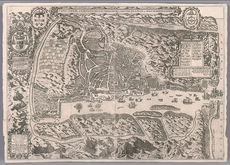
This map of Goa came in a three-part volume that revealed the secrets of Portuguese trade and navigation to the European world. It not only discussed maritime hubs in southern Asia, but also potential opportunities in the East Indies. This knowledge bank supposedly opened the doors for Dutch colonisation in Indonesia, and the British Raj on our shores. While that&rsquos a terribly unpleasant legacy for a map collection, there&rsquos something to be said for Linschoten&rsquos efforts&mdashhe was one of the first to show southern Asia in great detail.
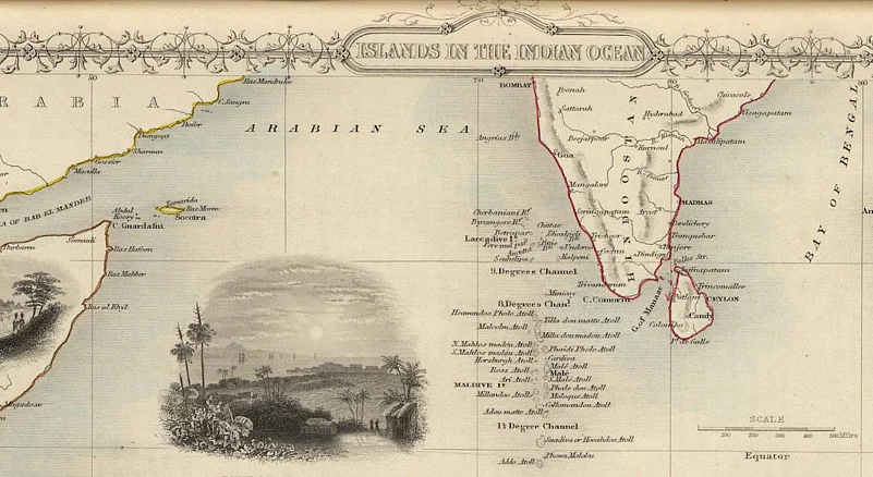
A charming summary of islands in the Indian Ocean, with drawings of key port towns for the uninitiated. We spot Galle in Sri Lanka, Port Louis in Mauritius, and (we&rsquore not sure why) the North Beach on Prince of Wales Island, Alaska. There&rsquos also a native Malagasay village, and a tiny waterfall on the French-administered Isle of Bourbon, now called Réunion. Perhaps the mapmakers were playing favourites
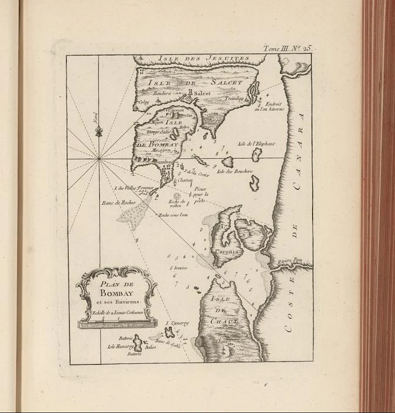
A view of Mumbai before land reclamation projects created the superlative landmass today. Changing hands from the Silhara dynasty, the Gujarat Sultanate, and the Portuguese occupation, the seven islands of Bombay, Colaba, Little Colaba, Mahim, Mazgaon, Parel and Worli were ultimately handed to England as part of a royal wedding dowry. We&rsquore told the East India Company later rented the islands for £10 a year.
This map was probably created after the original seven islands were merged&mdashit only shows Salsette and Trombay marked as a major separate island. The original seven now hold South Mumbai, while the latter makes up Thane and the suburbs.
If you can't already tell, spending just a few hours studying the Rumsey Maps can provide an unlikely yet brilliant primer on history, art and international relations. After poring through the India section, here are our key takeaways
- We can&rsquot escape biases today, and neither could early mapmakers. Stargazing, explorer accounts and limited public information were the few avenues for medieval artists, and they often put in their ideas of mythology and propriety into these maps to spice things up. Some of these elements can be deemed offensive today, so keep an open mind.
- The Oriental outlook can still feel a little uncomfortable, and lead to miseducation and prejudice. It&rsquos possible that an interest in the exotic led to more detailed mapmaking of Asia in the first place, but if you&rsquore going through medieval atlases for the first time, take the descriptions with a pinch of salt. An 1891 atlas I came across here had confidently erased Dravidian identity, declaring that all who lived below the Himalaya, Hindukush and the Caucasus were Caucasian, except for a few &lsquolow races&rsquo.
- After gazing through hundreds of Indian maps here, port towns and the British Presidencies were the clear winners when it came to regular updates and rich detail. Central and southern India, with large indigenous populations Not so much. Smaller French colonies like Chandannagar in Bengal also persistently show up, hundreds of years after their their relevance declined. It gives the impression that European representation was more of a concern than accuracy for the masses.
- This isn&rsquot exactly a takeaway, but as a geography nerd, I&rsquod be remiss to not share this tidbit. We&rsquove forever used Greenwich as the prime meridian, but did you know that before the future British empire, the Paris and Ferro meridians were used as the world&rsquos central longitude Ferro (El Hierro), part of the Spanish Canary Islands, was considered the westernmost point of the Old World, about lay about twenty degrees west of Paris.
India too has a long history of cartography based on celestial calculations and international texts, but our homegrown maps are yet to find a place in the Rumsey collection online.
To begin exploring this monumental archive, visit davidrumsey.com