Emptiness can be beautiful, and intensely terrifying. Every time I reached the top of one of the many passes that dot the Changthang plateau in Ladakh, I closed my eyes and held my breath, the blood pounding in my ears. I felt like I was floating in endless space. I opened my eyes, and the bright sunlight came flooding in. But the feeling persisted, that feeling of levitating in thin air.
The Changthang is a profoundly eerie and wonderful place, and not just because of the vast inland lake of Tso Moriri. The trail from Rumtse to Karzok by the Tso Moriri marks an important trade route from Leh to southeast Ladakh and thence to the Tibetan
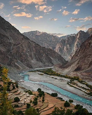
plateau further east and to Spiti to the south over the Parang La. Changthang is a marvellous desolation, the like of which Id never seen before. We walked with our mule train across the vast lands where Changpa nomads live with their pashmina goats and yaks.
We crossed the giant bowl of the salt lake of Tso Kar, past piles of salt washed up by the blue-black waves, while beside us rose a barrier of scree and rock peaks 6,000m high, dividing us from the vast Morey Plainsover which passes the Manali-Leh highwaymaybe the vast dusty bed of a giant lake itself.

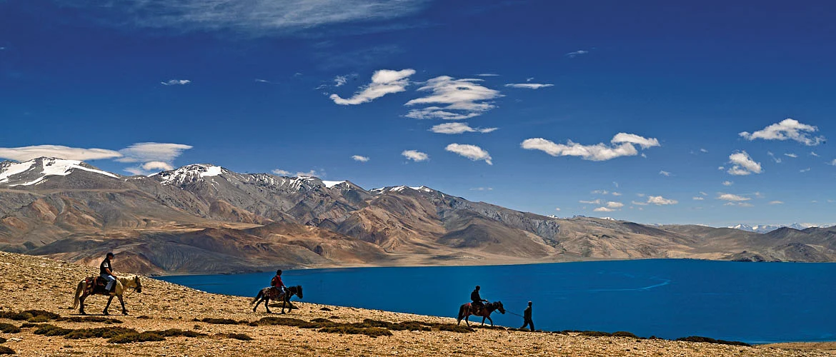
Strong, fresh and cold ice-melt streams punctuated our walk over extensive high and wide valleys of grazing grounds. These reminded me more of Arctic Tundra landscapes than anything else. In other valleys we saw packs of wild horses running in braided patterns, their manes flying, hooves kicking up the water in the stream. Above, in the passes, large grey wolves lurked, disappearing in a flash quite astounding for such large animals. And for almost the entire stretch of the trek, the clicks and whistles of fat little marmots dogged our steps, while their furry heads played peekaboo from their burrows. After over a week of hallucinatory plodding over surreal landscapes of menace and beauty, we finally reached a pass higher than all the rest, perched high up on the Mentok range, and got our first, breathtaking view of the storied Tso Moriri. Covering a distance of some 100 kilometres, this is probably the most quintessential trek in all of Ladakh. It takes in no less than seven passes over 4,800m high, thus living up to Ladakhs namethe land of passes.

This was my first visit to the trans-Himalaya, and I found that just like the landscape, the very experience of trekking changes in the rain shadow of the Great Himalayan Range. Whereas south of the Himalaya, the trails wind up from semitropical regions to the treeline and then to high alpine areas, the Changthang seemed to hang from the sky. It seemed not quite of the earththe skies were panoramic and big, the clouds low and stretched out. There were hardly any steep, craggy cliffs here, just unending slopes of gravel and coarse scrub, loose scree and grassy plains and marshes that looked like rolling meadows. The general desolation and the extreme altitude here places immense strains on the human body, so any walk here can only be done with full bandobast, which means pack mules, muleteers and a guide with at least one helper.
We started our walk from our Rumtse camp beside an age old wall of stupas that marked the end of the kingdom of Ladakh,and the beginning of the ancient Purang-Guge kingdom that had once ruled western Tibet (and Kinnaur and Spiti), and veered off up the Kyamar Chu valley. Our way lay past marshes dotted with orderly groups of Changpa flocks. The first of the passes, Kyamar La, marked the geological divide between central Ladakh and the Changthang. Looking west, the peaks of the Zanskar range like
Kang Yatse stood out. Further east, the rolling ranges that punctuated the high plateau came into focus. These ran more-or-less parallel to each other, separated by either large lake beds like that of Tso Kar, or intensely fast-flowing streams.

On some days, we crossed not just one pass, but two, which meant ascending some 2,000 feet, and then descending another 1,500 feet, only to repeat this process. Panting for breath in that wide wilderness, unable to realistically gauge distances in the shimmering air, the landscape seemed ripe with intent, brooding and alien. Was that flock of Kiang five kilometres away or ten Was that skyline the true pass Was that an enormous shaggy dog or a wolf Was that stiff-limbed figure lurching towards me a Ro-Langs, the Tibetan zombie of legend
The day would turn bright and sunny by 9amand by sunny I mean sunlight that flays the skin off an exposed arm or noseand come afternoon, a high, shrill wind would start, scoring our faces with a million tiny pinpricks of dust and burrowing into our mind like the ever-present scream of an enraged dakini. In that phantasmagoric landscape, it was difficult to tell fact from fantasy. The whistles of our constant companions, the marmots, sometimes took on a distinctly sinister pitch. As we walked, the moon waxed fuller every night until at the Changpa camp of Rajungkharu, it rose above a far mountain like a gigantic searchlight, turning the black night into an eerie bone-white landscape. If The Great Old Ones of Lovecraftian horror had descended from that gibbous moon that night, I wouldnt have been the least surprised.

Then there were the Changpa people. The entirety of the Changthang is dominated by them and their flocks. At major Changpa camps like Pongunagu and Nuruchen on the Tso Kar, Rajungkharu and Gyamalhoma, were raised their ubiquitous black and white tents. Their traditional black yak-hair tents are slowly giving way to the newer white ones made of a sort-of parachute material. There were other signs of their growing prosperity on the back of their pashmina trade. The most startling of these were their SUVs. I felt it was a trick of the mind when, while approaching Rajungkharu, I saw far off, the beetling shape of an SUV crawling over what seemed like a perpendicular slope. I learnt later that it was jeep service to ferry people to Leh for an audience with the visiting Dalai Lama.

At these camps, every morning would begin with the bleating of sheep and goat as the flocks were herded, counted and milked, before they set off for the days grazing. On Horlam La, a small, grassy pass between Nuruchen and Rajungkharu, a Changpa on a horse suddenly appeared, riding towards us full tilt. It was quite a charge. At the last moment he wheeled his mount around, grinned and, shouting a Juley, hared off. Later that day, we saw a band of horsemen galloping across the Spanglung Serpa river, raising the
dust. I felt like Id wandered onto a set of Crouching Tiger, Hidden Dragon.
The final days walk was probably the most euphoric one. Starting out from our highest campyet at the 5,150m Gyamalhoma, we threaded our way through a deep rocky defile, with surreal overhangs and a chilly stream passing through. As the valley climbed higher the peaks of the ice-plateau of the Mentok range came into view. We walked up through the gravelly hills and up to the Yarlung Nyau La, a whopping 5,450m high. And there, spread out some 3,000 feet below us, were the waters of Tso Moriri, all 120 sq km of it, a deep lilac carpet laid across a vast valley. Over it darted a multitude of low clouds, and across the lake rose the summits of Chamser and Lungser Kangri, the highest peaks in the Changthang. It was a Roerich painting in 3D. We raised a toast to the lake with some rum, and stumbled down the dusty slopes for the long walk into the void.
The Information
The Rumtse-Tso Moriri trek can be done in 7 to 9 days depending on acclimatisation and general ease. More so than other Ladakh treks, this is a full-service trek, and you will require pack mules and full provisions as well as a cook at least. The trails are well marked so you could do the trek without a guide. However, having a knowledgable guide makes a huge difference.
This article was first published in the June 2014 issue ofOutlook Traveller