Not all trails are created equal. Some are mere walks in the woods, while others are grueling tests of skill, stamina, and nerve. Some hikes are scenic; others are brutal. In this guide, we explore some of the world’s toughest hiking trails, from the Snowman Trek and Corsica’s GR20 to Angel’s Landing, Half Dome, and the high-altitude circuits of the Andes and Karakoram. The trails on this list cut across jagged ridges, steep forests, and exposed summits, where the margin for error is slim.
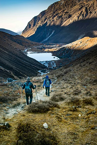
The Snowman Trek, Bhutan

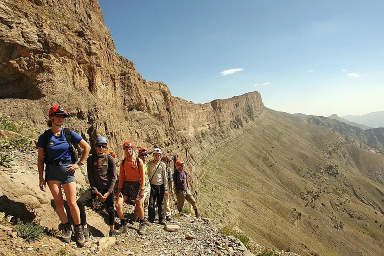
The Snowman Trek is widely regarded as one of the most demanding treks on the planet. Stretching approximately 347 kilometres (216 miles) across Bhutan’s remote Lunana region, it takes trekkers 25–30 days to complete. The route traverses 11 high mountain passes, many above 5,000 metres (16,400 feet), across rugged, isolated terrain. Weather is unpredictable, shifting from intense cold to sudden snow and rain. This trek is not for the faint-hearted; it demands exceptional physical fitness, mental resilience, and careful preparation. For those who undertake it, the journey offers an unparalleled combination of raw Himalayan wilderness, glimpses of Bhutanese culture, and the quiet satisfaction of completing one of the world’s toughest long-distance treks.
Challenges on the Trail
The Snowman Trek is demanding at every step. High passes above 5,000 metres make acclimatisation essential, while steep, rocky terrain tests strength and balance. Weather is unpredictable, with snow, rain, and cold appearing without warning, and the remoteness of the region leaves little room for error or emergency support.
Difficulty Levels and Altitude
Covering 347 kilometres over 25 to 30 days, the trek crosses eleven mountain passes, several over 5,000 metres. It is one of the most difficult treks in the world, suitable only for those with high fitness, technical skill, and endurance.
Highlights on the Trail
The rewards match the effort. Trekkers encounter sweeping Himalayan peaks, glacial lakes, and pristine wilderness. Remote Lunana villages, ancient Dzongs, and rare wildlife such as blue sheep add cultural and natural richness to the journey.
GR20, Corsica, France
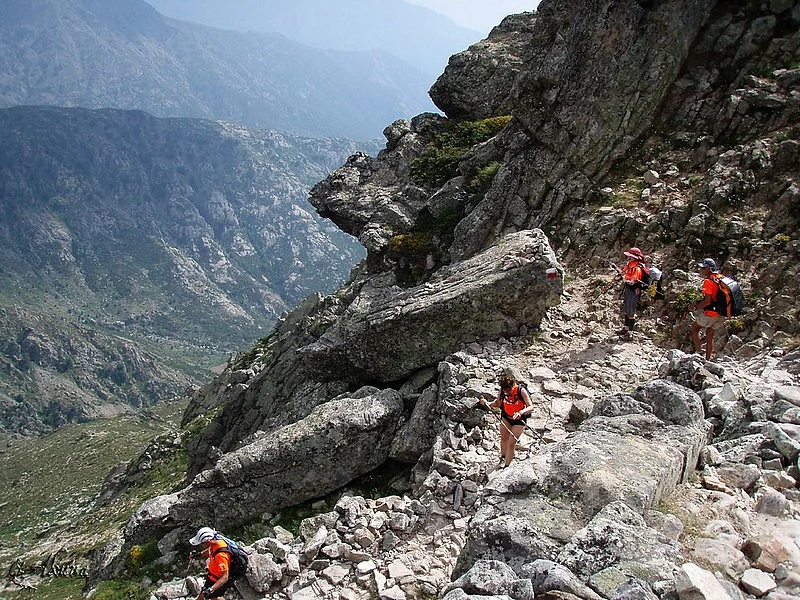
The GR20 is widely regarded as one of Europe’s toughest long-distance treks, stretching approximately 180 kilometres across the rugged mountains of Corsica. Running from Calenzana in the north to Conca in the south, the route typically takes between eight and sixteen days to complete, depending on fitness and pace. The trail is famous for its steep ascents, descents, and rocky sections, including technical climbs where chains assist trekkers across exposed slabs. The terrain is uneven and the weather can be unpredictable, with sudden thunderstorms, fog, or high winds adding to the challenge.
Challenges on the Trail
The GR20 demands stamina and focus. Steep ascents, rocky scrambles, and technical sections with chains test strength and balance, while changeable weather and remote terrain require preparation and vigilance.
Difficulty Levels and Altitude
The 180-kilometre route gains and loses around 12,000 metres in elevation. It is one of Europe’s toughest treks, suitable only for those with strong fitness and mountain experience.
Highlights on the Trail
The trek rewards effort with dramatic peaks, deep valleys, and views of Corsica’s wild interior. Remote huts and villages offer glimpses of local life, making the journey as culturally rich as it is physically demanding.
Angel’s Landing, Zion National Park, USA

Angel’s Landing is one of the most iconic and challenging hikes in Zion National Park in southwest Utah. The 5.4-mile round trip gains approximately 1,500 feet in elevation, culminating in a narrow rock fin with sheer drop-offs on either side. The final half-mile requires hikers to use chains for support as they navigate the exposed spine, demanding both strength and mental focus. Summer temperatures can exceed 100°F, and the trail offers little shade, making hydration and early starts essential. Despite its brevity compared to multi-day treks, Angel’s Landing is a physically strenuous and psychologically demanding climb, rewarding those who reach the summit with dramatic views of Zion Canyon.
Challenges on the Trail
Angel’s Landing tests both body and mind. The steep ascent and final chain-assisted scramble require strength and balance, while the narrow rock fin and sheer drop-offs demand focus and courage. Heat and sun exposure add to the difficulty, and crowded conditions can intensify the challenge.
Difficulty Levels and Altitude
The hike covers 5.4 miles with an elevation gain of roughly 1,500 feet. Though short, it is strenuous and exposed, suitable only for hikers with good fitness, sure-footedness, and a tolerance for heights.
Highlights on the Trail
The summit offers sweeping views of Zion Canyon and the surrounding red-rock cliffs. The sense of exposure and accomplishment on the narrow spine, combined with the park’s dramatic scenery, makes Angel’s Landing a memorable and iconic experience.
Mist Trail to Half Dome, Yosemite National Park, USA

The hike to Half Dome via the Mist Trail is one of Yosemite’s most iconic and demanding treks. The round trip covers 14–16 miles with nearly 4,800 feet of elevation gain, and most hikers require 10 to 12 hours to reach the summit and return. The final 400 feet involve a cable-assisted climb up a near-45-degree granite face, demanding both upper-body strength and mental focus. The trail is exposed, strenuous, and physically relentless, with steep granite steps along Vernal and Nevada Falls, a sandy ascent to the subdome, and a long approach through Little Yosemite Valley.
Challenges on the Trail
Half Dome tests endurance at every stage. The Mist Trail’s steep granite steps and long ascents push legs and knees to the limit, while the subdome and cable section demand upper-body strength, balance, and nerve. Exposure on the granite face and long hours of hiking add both physical and psychological strain, and unpredictable weather can further complicate the ascent.
Difficulty Levels and Altitude
The trail gains nearly 4,800 feet over 14–16 miles, with the summit at 8,846 feet above sea level. It is one of Yosemite’s most strenuous hikes, suited only to those with high fitness, climbing experience, and tolerance for heights.
Highlights on the Trail
The hike offers some of Yosemite’s most breathtaking sights. Hikers pass the misty 317-foot Vernal Fall, the 594-foot Nevada Fall, and the forested Little Yosemite Valley before tackling the subdome. The summit provides sweeping views of Yosemite Valley, Liberty Cap, and the surrounding high country, making the physical and mental challenge of the trail richly rewarding.
Cordillera Huayhuash Circuit, Peru

The Cordillera Huayhuash Circuit is a challenging multi-day trek through some of Peru’s most dramatic mountain landscapes. Covering 110–130 kilometres over 8 to 14 days, the route traverses high-altitude passes often exceeding 5,000 metres and campsites between 4,100 and 4,600 metres. Trekkers require strong physical fitness, prior multi-day trekking experience, and careful acclimatisation to cope with the thin air and cold nights. The trail winds past glacial lakes, towering peaks—including Yerupaja, the Andes’ second-highest mountain—and remote villages, offering a raw and secluded experience. Limited facilities along the route mean hikers must carry supplies, and preparation for cold nights and altitude sickness is essential. Despite its rigours, the circuit rewards those who reach its heights with unparalleled scenery and a profound sense of isolation.
Challenges on the Trail
The Huayhuash Circuit tests endurance and resilience. Long days over rugged terrain, high passes above 5,000 metres, and frigid nights demand careful pacing, physical strength, and proper gear. Remoteness adds another layer of difficulty, as trekkers must be self-sufficient and prepared for sudden weather changes.
Difficulty Levels and Altitude
Spanning 110–130 kilometres with high passes and campsites between 4,100 and 4,600 metres, the trek is considered moderate to strenuous. Only those with prior multi-day trekking experience, strong fitness, and proper acclimatisation should attempt it.
Highlights on the Trail
The route offers some of the Andes’ most breathtaking scenery. Trekkers encounter towering peaks, glacial lakes, and wildlife such as condors, vicuñas, and llamas. Cultural encounters with local settlements, natural hot springs at Viconga, and views of iconic peaks like Siula Grande make the journey both visually stunning and uniquely rewarding.
K2 and Concordia Trek, Pakistan

The K2 and Concordia trek is a demanding multi-day expedition through Pakistan’s Karakoram range, leading trekkers to the base of the world’s second-highest mountain, K2, and to Concordia, where the Baltoro and Godwin-Austen glaciers converge. Typically lasting 19–20 days, the trek begins in Skardu with a drive to Askole, the last motorable village, before following the icy, rocky Baltoro Glacier. Trekkers gain altitude steadily, reaching over 5,150 metres at K2 Base Camp, while being rewarded with spectacular views of K2, Broad Peak, Gasherbrum I, and Gasherbrum II.
Challenges on the Trail
The trek is physically and mentally demanding. Long days on glacier terrain, steep ice and rock sections, and the thin air at high altitude test endurance and stamina. Weather can be unpredictable, ranging from warm daytime sun to freezing nights and sudden snow at higher elevations. Remoteness makes self-sufficiency essential, with local guides and support crews critical for navigation and safety.
Difficulty Levels and Altitude
Over 12–13 days of trekking, participants cover challenging glacier paths and gain more than 5,000 metres in altitude. While no technical mountaineering is required for the main route, the trek is graded as challenging, suited only to fit, experienced high-altitude trekkers prepared for extended physical exertion.
Highlights on the Trail
The trek rewards effort with breathtaking glacial vistas and panoramic views of four 8,000-metre peaks from Concordia. The journey features dramatic icefalls, towering rock formations such as the Trango Towers, and the poignant Gilkey Memorial. K2 Base Camp offers an unparalleled perspective of the “Savage Mountain,” making the trek a once-in-a-lifetime high-altitude adventure.
FAQs
What are the toughest hiking trails in the world?
The toughest hiking trails include Bhutan’s Snowman Trek, Corsica’s GR20, Angel’s Landing in Utah, Half Dome in Yosemite, Peru’s Cordillera Huayhuash, and the K2 and Concordia trek in Pakistan. These routes test endurance, skill, and mental resilience.
How difficult are these trails to hike?
These trails are considered extremely challenging, often featuring high altitudes, steep ascents, rocky terrain, and multi-day treks. They require excellent physical fitness, preparation, and, in some cases, technical climbing skills.
When is the best time to hike these extreme trails?
Timing varies by trail: late May to September is best for the Cordillera Huayhuash; July–August for K2 and Concordia; late spring to early autumn is ideal for the GR20 and Half Dome. Always check local conditions before planning.
Do I need special gear or permits?
Yes. Most of these treks require proper hiking boots, warm clothing, and safety gear. Some, like Half Dome and Angel’s Landing, require permits, while multi-day treks often need camping equipment and emergency supplies.
Are these trails suitable for beginners?
No. These are high-difficulty trails designed for experienced hikers with strong endurance, mountain experience, and the ability to navigate remote, high-altitude terrain safely.