It was a surprisingly cool April night in Devprayag, an unremarkable concrete hill-town perched above the turbulent confluence of the Bhagirathi and Alaknanda rivers. The sky was clear, a million stars seemed tacked onto the inky blackness, and a sliver of moonlight reflected off the pillars of the Chaukhamba peak in the distance. It had been a very long drive up from Delhi, but we were now firmly in the mountains, and Sanjoy was snoring like a cricket.
This part of Garhwal is known for its religious spots &mdash the Panch Kedars and the Char Dhams &mdash and most treks are better known as pilgrimages. But if you&rsquore an atheist like me, and fancy yourself a birdwatcher and hiker, you could very easily chalk out some beautiful treks through old-growth forests. Our plan was to start trekking the next morning from Sari village, a two-hour drive from Devprayag, and head towards the Mandal valley over the course of five days.
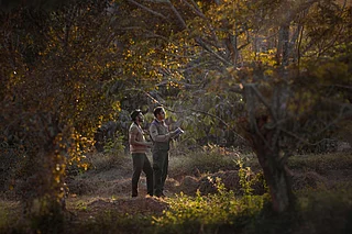
Unlike most other treks I&rsquove been on this one was completely organized &mdash porters carried our luggage to campsites leaving us to carry just a daypack our guide Surendra Bisht (also known as Suri) led the way, stopping every once in a while to point out another peak which had appeared over a crag while Yashpal Negi, the birdwatcher, whispered an average of 30 Latin names an hour into my ear. There was packed lunch to be had on the walk, the promise of good food for dinner and ready tents when we arrived at the campsite tea, filter coffee, nimbu pani on demand, and camp fires in the evening. The arrangements stopped just a little bit short of us being carried in palanquins.
Sari village to Deoriatal (5,904ft, 2hrs)
Sari is a small sleepy village beyond Ukhimath, a few kilometres off the road that goes towards Kedarnath. It&rsquos a mix of modern concrete-box architecture and traditional stone houses. A patchwork of terraced fields planted with wheat stretch down from the village to the point where the mountain falls sharply into the valley of the Mandakini river, and above the village for about a kilometre, at which point dense forests take over.
A bridle path ascends through the village and the fields. We set a leisurely pace, giving ourselves time to get into the rhythm of the climb. As we got higher the hubbub of conversation from the roadside tea stalls faded away leaving only the rustle of leaves and the gentle wheeze of the breeze as it forced its way through narrow gaps in the rock faces. Brilliant red strokes of rhododendron trees in bloom appeared on the forests of the adjoining hill. It was hot in the sun, and a trickle of sweat made its way down my forehead. The snows of the Chandrashila peak, our destination two days hence, glistened impossibly far away.
The path made its way towards a cleft in the hill, entering, after an hour of climbing, a dense forest of rhododendron, banj oak, and deodar. Here the sunlight filtered through the canopy in small patches, the path was covered in fallen leaves, and the probing tap-tap-tap of the Himalayan woodpecker rose desultorily from hidden corners.
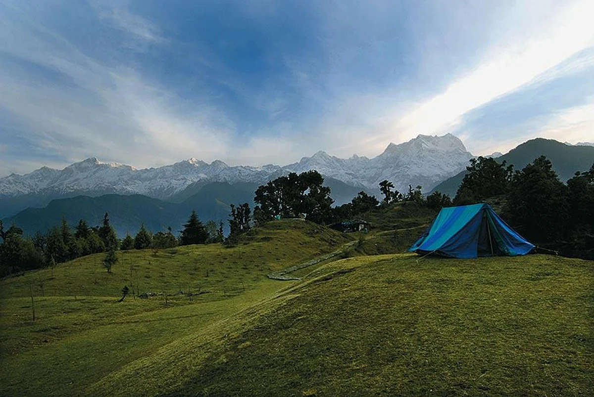
A little later the path levelled out, and then just as suddenly we emerged into a clearing, at which point two things happened &mdash the green waters of a small mountain lake appeared a little below us, and the snows of the Chaukhamba, Kedar and Gangotri range of peaks which had seemed so distant from Rudraprayag, emerged magically within touching distance, towering above the lake. We made our way towards two single man tents, erected a little above one bank of the lake. By the time we got there, two camping chairs and a camping table with a plate of biscuits and two mugs of coffee had been put out.
Deoriatal to Barniyakund via Chopta (9,840ft, 9hrs)
I poked my head cautiously out of the tent, shivering with every movement. A pale pre-dawn light lit up the sky, but the sun hadn&rsquot hit the mountains. There was silence all around. A gaggle of Bengalis wearing monkey caps stood huddled on one bank, waiting for sunrise. As I was debating going back to sleep a mug of hot tea was deposited in my hands, and I retreated back into the tent.
When I poked my head out again, the sky was ablaze. The first rays of the sun had struck the massive pillars of Chaukhamba. The snows of the peak rippled in the waters of the lake, and the pee-pee-ah of a large hawk cuckoo rose in pitch to a hysterical crescendo as the sun rose past the peak.
Sanjoy was already up, and much to my chagrin, on his way to the toilet tent &mdash that epitome of camping luxury. A lavish breakfast of porridge, omelette, toast with a choice of jams, peanut butter and cheese, fresh fruit, and hot milk laid out against the equally lavish backdrop of forests, the lake and snowy peaks awaited us.
At eight, we were ready to move. The kitchen team would pack up, get back to the road, and drive to the next campsite at Barniyakund. The rest of us would walk. The climb would take us straight up to a ridge, a steep ascent of nearly 2,500ft, after which we would continue along the spur for a couple of kilometres. We would then descend about as much as we had climbed, to the Akash Kamini river, and then climb the same amount once again to the Martoli Bend, a little before Chopta.
The ascent was tortuous, coming as it did immediately after breakfast. The air became thinner, my breathing more laboured, and I slowed down considerably with every switchback. Sari village reappeared more than a kilometre below us, and views of valley after valley stretched out from where we stood to eternity. There was a nip in the air, but I was soaked. As I huffed and puffed, village women carrying huge bundles of leaves of the moru oak came skipping down the path, disappearing quickly around the bends.
The climb got steadily more difficult. The rock-strewn pathway climbed relentlessly up. The first spindly fir trees appeared as we reached the top of the ridge. By now the sun was high up in the sky, and the birds had fallen silent. As we moved from the right flank of the ridge to the left, there was a stunning change of scenery &mdash the far views of various valleys were replaced by snowcapped peaks. They were now forbiddingly close. I could see every snow-accentuated ridge, and every gully. I stared stunned, and then sat down to take in the view.
We were entering a patch of forest that had run amok. Huge trees towered hundreds of feet above us. The path was strewn with fallen tree trunks. Moss covered every rock surface, and the thick smell of decaying vegetation hung in the air. The first maple trees appeared, covered in the dense cloak of fresh green leaves. A monal pheasant let out an alarm cry and streaked across the path, its brilliant blue feathers glinting in the sun.
Rounding the last hill we began our descent towards the river. The path hugged the side of the hill, meandering from one vast rolling bugyal (alpine meadow) to another. Chains of red and pink rhododendron trees surrounded the bugyals, their canopies so heavy with flowers that you could barely see the branches. The grass was a young green having grown afresh after the thaw. A little after three, we stopped in Roni bugyal for lunch. We&rsquod been walking for nearly seven hours, and I was starving. I wolfed down my packed lunch of sandwiches, an apple, orange, and a bar of chocolate. &ldquoWe&rsquove got another two hours to go,&rdquo said Negiji standing up.
At Martoli a car was waiting for us. From here it was a level three-kilometre drive to the campsite at Barniyakund &mdash a beautiful meadow flanked by forests on one side, and views of towering peaks on the other. That night I sat by the campfire, warming my legs, sipping hot tomato soup, and munching papads. Soon thick black clouds were rolling down from the mountains above us, obscuring the stars and sending a bone-chilling wind down the valley.
Chopta to Chandrashila and back (13,564 ft, 6hrs)
By the morning the sky had cleared up, allowing us to attempt the 3,500ft climb to Tungnath, the highest of the Panch Kedars. A stone pathway framed by flowering rhododendrons leads all the way from Chopta to Tungnath. It&rsquos a gradual climb &mdash as you get higher the views get more and more spectacular and the rhododendron varieties change, reducing in size till at 12,000ft they&rsquore just bushes one foot high.
The going was slow &mdash and we stopped every 10 minutes to take in mouthfuls of air. The fir trees ended at about 10,500ft, after which patches of snow began appearing on the brown rocky ground. Monal pheasants wandered on the margins of the snow searching for insects in the grass, while a Himalayan pika, a marmot-like creature that looks like a cross between a mouse and a hare, chased a partner across a rock wall.
Two hours later we were at Tungnath. Negiji and I decided to press on towards Chandrashila without stopping. There was too much snow on the pagdandi from Tungnath to Chandrashila so we decided to try another route. We found a few grassy patches but there was no avoiding the snow. Slipping, sliding and falling, we reached a small peak a little below Chandrashila. Beyond this the path disappeared under snow. As we stopped panting, the absolute silence that you find at this altitude blanketed us. Even the wind seemed to blow quietly. The lone cry of a crow ricocheted feebly off the mountain.
Around us lay strewn a panorama of peaks &mdash Nanda Devi, Trishul, Dunagiri and Hathi stacked side by side in front, obscured partly by clouds, while behind us lay Chaukhamba, Kedar peak and the Gangotri peaks &mdash our constant companions through the trek. The Chandrashila peak rose straight above us, the little hut on top of the peak appearing like a fleck in the clouds.
It had started raining by the time we got back to the campsite. We joined a couple of people who&rsquod taken shelter in a small shop by the roadside. At four o&rsquoclock a hailstorm turned the mountainside white. By 430 the hail had melted. And at five hot pakoras and tea was sent up to us from the camp. It was warm by the fire, and the rain fell gently on the leaky thatch roof &mdash in my tired state the small drops felt like little clear thoughts falling through the mind to disappear in the mud floor.
Chopta to Mandal (5,100ft 8hrs)
At 10 in the morning, the clouds started clearing and the rain let up.
Birds started appearing &mdash a speckled finch foraged in front of one of the herders&rsquo huts at Barniyakund. And as I was making my way towards the car, I saw the majestic figure of a Himalayan griffon alight on a tree. It spread its massive white and black wings out to dry in the first rays of the emergent sun, and looked up at the low-slung clouds.
We were to drive nine kilometres from the camp, and then start our descent towards the Mandal valley. As we started walking, the forest closed in immediately on us. Water dripped off rocky overhangs, onto petite wild flowers that lined the path. The rain had made the moss-covered stones even more slippery, and every step was a prayer and a careful negotiation. A few hours of this and I&rsquod had my fill &mdash we decided that it would be far more fun to walk the remaining distance on the road.
It was a good decision &mdash the deserted road wound through dense forests brimming with wildlife. Five minutes down we heard the rustle of leaves and the phlegmatic call of a barking deer as it ran from the road in alarm. A Jerdon&rsquos Baza sat on the moss-covered branches of a dead tree, it&rsquos majestic white-tipped crest displayed sideways. And as we walked further a male-female pair of Kalij pheasants scurried into the undergrowth. They appeared a couple of times during our walk &mdash always tantalisingly close, but vanishing in a split second.
At four o&rsquoclock, Mandal village, located on the banks of a stream at the intersection of three mountains, appeared below us. The foliage had changed once again &mdash now there was a preponderance of rust-coloured walnut and kaphal. It had started drizzling. The tiredness was telling on me and Suri. By five it started getting dark, and I could see sheets of rain falling in the far valley.
Mandal to Ansuya village (6,900ft, 5hrs)
Ansuya village is located high on a hill, a five-kilometre ascent from Mandal. The path to it goes through Mandal, past old stone and slate-roofed houses, water-driven flour mills, and sun-drenched terraces where people sit soaking up the morning sun, and then through dense patches of forest.
As I entered the village, an old man sitting on the steps of a house stopped me, and introduced himself as the pujari of the temple. &ldquoPlease take a photograph of him,&rdquo he said pointing to a man in a tattered sweater washing utensils by a stream. &ldquoAyye murkh,&rdquo he screeched, &ldquothey&rsquore going to take your photograph to Delhi.&rdquo The murkh looked petrified. &ldquoLook at him,&rdquo chortled the pujari, &ldquoin those tattered sweaters.&rdquo In the meantime, the murkh had finished washing the dishes and was rolling on the grass in front of the cottage. &ldquoHe&rsquos like a grain of fat, unpolished rice,&rdquo said the pujari loudly, while the murkh smiled indulgently and blew indolent smoke rings into the air.
It was our last night at the camp. Suri was in a fine mood &mdash regaling us with tales of dead trekkers whose ghosts wander various campsites. The dinner was more elaborate than usual&mdashthe cook had driven all the way to Gopeshwar to buy us a desi murgi. There were two different subzis, dal and rice, and kheer for dessert. Even the crickets were putting on a show &mdash their chirping rising in orchestral grandeur. The sky above had cleared. The candles on the table flickered in the breeze, the deep chuckle of a nightjar rose from the forest, and the lights of Gopeshwar twinkled like fireflies on a distant mountain.
The information
Route
Delhi-Rudraprayag-Sari village-Deoriatal-Barniyakund (Chopta)-Chandrashila (and back)-Mandal-Rishikesh-Delhi.
The trek
The trek from Sari village to Deoriatal is short and easy. Deoriatal to Barniyakund (the campsite beyond Chopta) is a long walk, and can be strenuous if you&rsquore not fit. The climb to Tungnath from Chopta is relatively easy &mdash and shouldn&rsquot take more than 3hrs. It&rsquos a steep climb from here to Chandrashila, but worth it for the views from the top. It&rsquos best to do part of the Barniyakund to Mandal walk along the road, especially if you want to do some birding &mdash descents along the bridle paths can be a little too steep. The walk from Mandal to Ansuya village is only steep in short sections.
What to carry
While trekking you&rsquoll only be carrying a daypack, so toss all your stuff into a large duffel bag for the porters to carry. Remember to carry your own torch, waterproof gear, towel and warm clothes. Everything else, including sleeping bags, is provided.
When to go
The best time to do this trek is from April to end-June and in September-October. It can get too cold during the winter, and too wet during the monsoons.
Operator
Many operators organise treks on this route, but we used Countryside Outdoor Programmes (022-24441513, 24442944 www.countrysideindia.com). They offer 7N/8D fixed departures (ex-Delhi by train from Delhi to Haridwar) for Rs 17,450 per person (check their website for departure dates and a detailed itinerary). They can also organise the trek especially for you (the cost will go up), provided you inform them at least 15 days in advance.
Birding
Yashpal Singh Negi, who runs the Mandakini Magpie Birdwatchers Camp (Rs 500 01364-268344, 9412909399) in Kakragad village near Rudraprayag, is a mine of information on the birds of the area. Countryside can arrange for him to accompany you on the trek for an additional Rs 750 per day.